GEOGRAPHIC INFORMATION SYSTEMS (GIS) CERTIFICATE
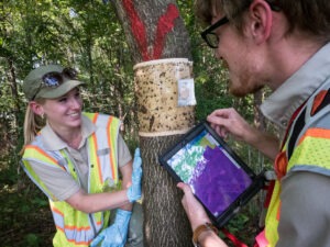
GIS is used by many government agencies – here scientist from the US Department of Agriculture study insects with the help of GIS – Photo from USDA
Program Description
Geographic Information Systems (GIS) is a computer-based system that integrates geographical data with descriptive data for the mapping, analysis, and assessment of real-world problems. GIS professionals apply fundamental concepts of geographic information science and technology to prepare maps and visualizations. The maps and visualizations are used to display data and applied to find solutions for real-world problems. This program provides students with the concepts, methods, and applications of Geographic Information Systems (GIS) using project-based training and industry-standard software and hardware.
What can you do with a degree in GIS
GIS and Geospatial Analysis allow students to integrate geography, data, and systems to solve a wide range of problems for government, business, healthcare, insurance, law enforcement and other industries.
Typical GIS Employers
- Government (Federal, State, Regional)
- Utilities (Electrical, Telecommunications)
- Environment and Natural Resources
- Public Safety
- Transportation and Navigation
- Surveying, Engineering, Construction
- Health, Epidemiology, and more…
Required Courses
- GEOG10 Introduction to Geographic Information Systems
- GEOG11 Spatial Analysis and Modeling in GI
- GEOG12 Cartographic Design for GIS
- GEOG13 Introduction to Web GIS Application
- COMSC3 Introduction to SQL Programming
Elective Courses
• INTRN45A First Semester Internship
• COMSC4 Python Programming
Course Descriptions
GEOG10 Introduction to Geographic Information Systems
This course provides an introduction to the concepts, methods, and applications of Geographic Information Systems (GIS). It emphasizes the techniques used to capture, store, query, analyze, and display spatial data. Specific topics include applications of GIS, geographic information and scale, coordinate systems, geospatial data models, data classification and symbolization, query and selection, cartographic design, data acquisition, data quality, geoprocessing, relational databases, metadata, spatial analysis, and GIS software.
GEOG11 Spatial Analysis and Modeling in GIS
This course provides a survey of the various concepts, approaches, and tools involved in analyzing and modeling spatial data using Geographic Information Systems (GIS). It emphasizes using spatial and statistical analysis, geoprocessing, and spatial modeling to investigate spatial distributions and relationships, answer spatial questions, and solve spatial problems. Specific topics include attribute and spatial query, geoprocessing, model building, distance and density surfaces, cluster analysis, network analysis, map algebra, surface interpolation and resampling, hydrologic analysis, 3D display/animation, and regression analysis.
GEOG12 Cartographic Design for GIS
This course provides an introduction to map design and production in the context of Geographic Information Systems (GIS). It emphasizes the concepts and methods associated with designing and producing thematic maps. Specific topics include data standardization and classification, symbolization, map projections, map elements, typography, cartographic design, thematic mapping techniques (choropleth, proportional symbol, dot, isarithmic, and multivariate), color in cartography, history of cartography, and map reproduction. Map critique sessions are also held.
GEOG13 Introduction to Web GIS Applications
This course introduces the development of Web-based Geographic Information Systems (GIS) solutions. Map authoring and Web service management tools are used to teach the techniques of creating, managing, maintaining, and deploying Web map services. It also introduces several options for using published Web map services for Web-based and mobile mapping applications.
COMSC3 Introduction to SQL Programming
This course introduces students to database design and management in GIS. Topics include conversion fundamentals, modeling techniques, and strategic planning. It examines various types of spatial data, and tabular data applicable to GIS, as well as relevant issues such as hardware and software requirements. Particular attention is paid to determining appropriate methodologies, conversion plans, and data assurance procedures.
COMSC4 Python Programming
This course provides the concepts and skills necessary to become a proficient GIS user, using the Python scripting language to develop commonly used GIS procedures and functions. Topics include GIS methods for querying and selecting geographic features, working with selection sets, editing tables, creating automated map sets, and performing geoprocessing operations.